UT4M 180 Challenge: Four Massifs, Four Days
Activity stats
The UT4M — Ultra Tour des 4 Massifs — is a race that circles Grenoble across the four mountain ranges surrounding the city: Vercors to the southwest, Taillefer to the southeast, Belledonne to the east, and Chartreuse to the north. The 180 Challenge strings them all together — one massif per day, four days straight, roughly 180 km and 11,600 m of vertical gain. Around 300 runners lined up for it that year. By the fourth day, only 208 made it to the finish — nearly a third dropped out along the way.
Living in Grenoble, I really wanted to do the tour at least once. There’s something fun about the idea of going around the entire city on foot and coming back home. I didn’t think I could do it in one go, so having a rest day between each stage was really welcome. It’s a format that makes you want to try it — maybe more accessible too.
Overview
| Stage | Massif | From → To | km | D+ | D- | Time | Rank |
|---|---|---|---|---|---|---|---|
| 1 | Vercors | Seyssins → Vif | 39.8 | 2,710 | 2,650 | 5:26:42 | 37th |
| 2 | Taillefer | Vif → Rioupéroux | 50.6 | 3,390 | 3,150 | 7:45:29 | 38th |
| 3 | Belledonne | Rioupéroux → St-Nazaire-les-Eymes | 48.4 | 2,900 | 3,160 | 8:41:07 | 49th |
| 4 | Chartreuse | St-Nazaire-les-Eymes → Grenoble | 41.4 | 2,630 | 2,690 | 6:49:13 | 52nd |
| Total | 180.2 | 11,630 | 11,650 | 28:42:31 | 52nd |
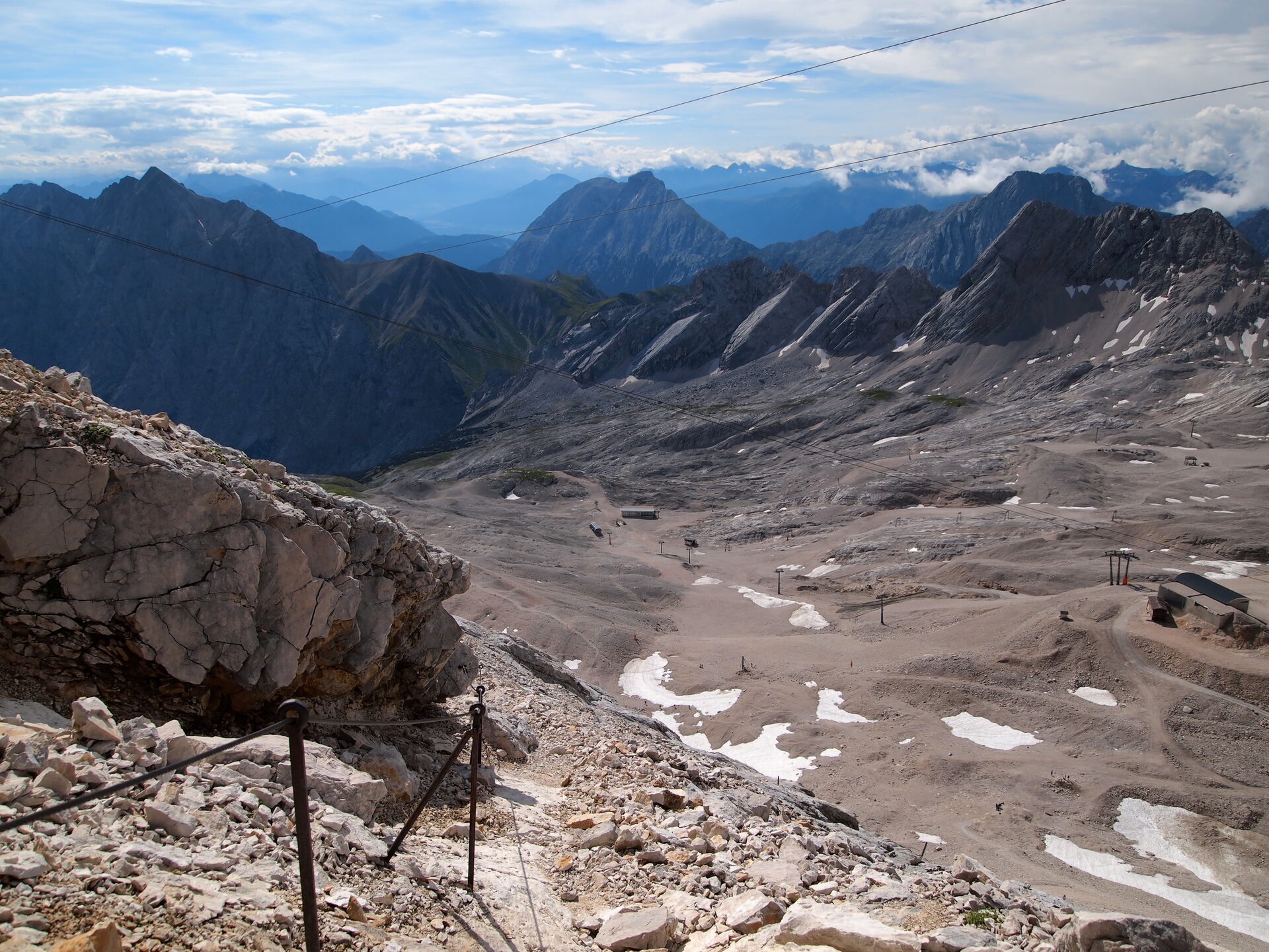
Day 1 — Vercors
Vercors: Seyssins → Vif
39.8 km | 2,710 m D+ | 2,650 m D- | Cutoff: 12h | Finish: 5:26:42 (37th)
The start is from Seyssins, right next to Grenoble — easy to reach by tram, and the start time wasn’t too early either. Convenient.
I felt really good, actually. Well-rested legs, even though just the week before I had finished the Grande Traversée des Alpes on foot as a hike. So there were already quite a few kilometers in the legs, but I was confident I could finish the challenge. When I thought about it, it would end up being roughly the same number of kilometers per day as my usual hiking days. The main difference would be that this time I’d be running instead of fast hiking. I told myself it should be fine.
The first stage kicked off with a big climb straight up to Saint-Nizier-du-Moucherotte, which I know pretty well — I’ve been up there several times before. I had a good rhythm on the climb and placed myself in a fairly strong position — 28th at the top of Saint-Nizier. Then on the descent, as always, I started losing ground. Between the two summits of the day, several people caught back up with me. By the time I reached Pic Saint-Michel at 3:48:55, I’d dropped to 39th — eleven places lost on the descent. From there I went down at my own pace, but not fast enough unfortunately — I got passed quite a few times, even though I stowed the poles and tried to fly down the trail as quickly as I could.
Arriving at Saint-Paul-de-Varces, I knew there was still one more climb and that I might be able to pick off a few runners on the way up. I managed to pass some of them, and then held the gap through the final descent into Vif and the flat finish to the end — clawing back to 37th.
I finished the stage in 5:26:42, 37th overall. Pretty satisfied with my race. Drove home, ate a mountain of pasta, elevated the legs, and tried not to think about the Taillefer waiting in the morning.
Day 2 — Taillefer
Taillefer: Vif → Rioupéroux
50.6 km | 3,390 m D+ | 3,150 m D- | Cutoff: 13h | Finish: 7:45:29 (38th)
A new massif for the second day: the Taillefer. We started roughly where we had finished the day before. This was one of the biggest days, with a lot of elevation gain and especially elevation loss, and a distance closer to 50 km rather than 40 — which would add several more hours of running.
The start from Vif was a bit boring, honestly. It goes quite fast on a good stretch of flat for the first few kilometers. Then there’s a small climb before arriving at Laffrey, at the Lac de Laffrey (40th at the checkpoint), which was a good opportunity to stop at the aid station. From there, I knew it would climb almost all the way up to the Taillefer. I found my rhythm and things went well — actually gaining a few places through the long climb, passing through Pas de la Vache (39th), Lac du Poursollet (38th), and up to Chalets Barrière where I was 36th. I had the impression of running with the same people as the day before — I kept recognizing familiar faces.
Then we arrived at the Plateau des Lacs, Lac Fourchu, which also gave some relief to the legs. It wasn’t pure climbing or pure descending — a bit of rolling terrain, which was actually quite pleasant. Until we reached the big descent. Almost a vertical kilometer downhill, more than 1,000 m of drop in one go. It was pretty violent and brought us straight into the finish town for the day.
There was a road crossing near the end, and I learned later that the timing actually stopped at that crossing. But I hadn’t understood that during the race, so I kept running afterwards — when I could have just walked to the finish since the clock had already stopped. Oh well.
I would have liked to get a massage at the massage stand, but it was already pretty full. So I decided to take one of the first shuttles back to Grenoble instead. Unfortunately we ended up stuck in traffic, and it took longer than expected to get home. I got back to the apartment around early evening — not too bad, but already a bit late. Iced everything that hurt and set the alarm for an obscenely early time.
Day 3 — Belledonne
Belledonne: Rioupéroux → Saint-Nazaire-les-Eymes
48.4 km | 2,900 m D+ | 3,160 m D- | Cutoff: 13h20 | Finish: 8:41:07 (49th)
The third day, and one of the most beautiful. The Belledonne massif. It starts directly with a vertical kilometer straight up to the Plateau de l’Arselle. Since there are two races running at the same time — the single-day stage race and our multi-day challenge — the organizers use staggered starts to avoid bottlenecks on the narrow trails. This suited me well, because I really hate waiting behind people on climbs, especially where I tend to go a bit faster. We started a little earlier and the climb went well — I reached the Plateau de l’Arselle in 1:28, sitting 35th.
At Arselle, we met up with runners from the 100 km race that had started the same day. From there we headed straight for the Croix de Chamrousse. When we arrived at Chamrousse, there were enormous crowds — it must have been the moment where nearly all race formats converge. We found ourselves on the Belledonne trails in a nearly endless human chain, as far as the eye could see. This was definitely not a day where you’d find yourself running alone. I passed through the Croix de Chamrousse checkpoint at 2:31, still 35th.
From there, I knew there would be an almost continuous climb all the way to the highest point of the entire challenge: the Col de Freydane at 2,660 m. I reached the col at 4:37 into the stage, still holding 35th. But from there things started pulling hard in my thighs. The soreness from the day before, or even the two previous days, was catching up. It was on this descent that the pain in my left quadriceps started, and it would follow me for the rest of the day.
I descended slowly, dropping to 41st by Pré Long and all the way to 49th by the finish at Saint-Nazaire. But I told myself it didn’t matter — what mattered now was finishing. I wasn’t racing for the overall ranking anyway. The descent was just incredibly long. From 2,700 m down to nearly valley altitude at 200–300 m, that’s more than 2,000 m of negative elevation. There were a few small climbs here and there that gave some relief to the legs, at least changing the sensation. But the descending stretches felt endless.
Then you have to cross the whole valley on a false flat to reach the finish town. And there, I was genuinely asking myself: will I be able to continue tomorrow? Because everything hurt.
But unlike the other days, I had the chance to sleep at friends’ place — they were kindly hosting me, since they were running the single-day Chartreuse stage the next day. This was a relief. It saved me the shuttle ride back to Grenoble, which meant much more time for recovery. So that night I stayed on site, and I was ready the next morning for the last day.
Day 4 — Chartreuse
Chartreuse: Saint-Nazaire-les-Eymes → Grenoble
41.4 km | 2,630 m D+ | 2,690 m D- | Cutoff: 12h | Finish: 6:49:13 (52nd)
The last day. I woke up hoping my leg would feel a bit better, but the pain hadn’t gone anywhere. I had a moment of genuine doubt about whether to even start, knowing I’d be suffering for 40 km with this leg. But I started anyway.
Same pattern as the other days: a big climb straight away. And in the climb, things were actually going well — no particular problems. I reached Emeindras at 1:37, 50th. If only it could just be climbing all the time, it would be so much better. Everything went fine all the way up to the high point of the day at Chamechaude. And then the long descent toward Grenoble began, with a small climb in between.
I had already lost quite a bit of time on the Chamechaude descent. I could feel I wasn’t running well — off balance because of the leg. I was getting passed, but it didn’t matter. It just didn’t matter. I kept going.
I made it to Le Sappey-en-Chartreuse at 4:08 (51st), where I took a small break and ate a bit before attacking another climb. On the way up I managed to catch some other runners — this was the climb to the Fort du Saint-Eynard. I passed through Col de Vence at 5:28, still 51st. Then came the fairly long descent from the fort, followed by a short false-flat uphill section, and finally the last descent toward Grenoble.
I arrived in mid-to-late afternoon — 6:49:13 for the stage, 28:42:31 total for the four days, 52nd overall. And that was the moment to celebrate a little — the end of this day, and above all the end of these four days.
The numbers
| Total distance | 180.2 km |
| Total elevation gain | 11,630 m |
| Total elevation loss | 11,650 m |
| Total time | 28:42:31 |
| Overall ranking | 52nd / 208 finishers |
| Days | 4 |
| Highest point | 2,660 m (Col de Freydane) |
In summary
It was a great experience, but truly intense. The fact that you do it over four days and run during the day rather than at night has a reassuring side to it. It means you can have a proper meal in the morning and in the evening when you get back, and have some time to recover a little. Even though in practice, it can still be hard to properly recover from one day to the next — the efforts are quite significant, with a lot of kilometers and elevation.
On top of that, you have to account for all the travel. Taking the official shuttles, you need to allocate time for that: getting to the shuttle pick-up point, waiting, the ride itself, and then waiting again before the race starts. It can easily add an hour and a half each way. That makes for a fairly late return. In my case, I think I got away with it reasonably well, but for someone who runs a bit slower, closer to the cutoffs, it can be quite intense. You end up finishing late in the evening, and on top of that you still have to get home — maybe arriving around 10 or 11 PM, and then waking up the next morning at 5 AM to catch the shuttle again. That can be exhausting.
Something to keep in mind if you’re thinking of doing it too, but expect to take a bit more time each day to finish the stages. Happy running!